


Marble Mountain - East Ridge
|
|

Trip Report [hide]
On Wednesday I skipped out of work and headed over to CSU to rent some gear. I needed a really warm sleeping bag, some snowshoes, and a pair of gaiters. With the stuff in hand I turned the car south and headed out of Fort Collins to Westcliffe to meet Alan and Barry. The weather was really crappy - windy and rainy in Fort Collins - and I hoped it would improve on the way south. I timed the drive pretty well and missed rush hour in Denver and cruised through Castle Rock.
I pulled into Westcliffe right about 5:00pm. I drove through town and pulled into our appointed meeting spot: the Diamond Shamrock. I called Alan and Barry on their respective cell phones - neither was answering. I left them messages that they could find me at Pizza Mania, and if I didn't see them ahead of time I'd meet them back at the Diamond Shamrock at 7:00pm (our appointed meeting time if we couldn't reach each other by phone).
I ordered a magnificent calzone and a beer at the pizza place and by the time I'd eaten half of it Alan and Barry showed up. They hadn't gotten my messages, but had heard good things about Pizza Mania and had chosen it to have dinner and wait for our appointed meeting time. We shot the shit and ate dinner before heading back up to the campsite.
On the way out to the campsite near Rainbow Trailhead we stopped at the Diamond Shamrock to use their restroom and lighted picnic table to sort out our gear. I'm sure we looked like a bunch of melvins with all or stuff spread all over and Alan trying to figure out his new tent heater but it was worth it to get all our stuff sorted out so that we'd be ready to roll first thing in the morning. I transferred all the stuff I would need to Barry's truck and then I followed them to the lower South Colony Lakes Trailhead. I parked my car there and piled into Barry's truck.
The drive up to the campsite was very interesting to say the least. We made it up through the first part without trouble, but then once we got into the trees the going got more difficult. The road is treacherous enough in optimal conditions, but imagine it with three inches of snow and in the dark! In a couple of the rougher, steeper sections Alan and I got out and Barry gunned it up the hill. When he would lose traction Alan and I would push. After several tries we managed to make it up to the campsite that Barry and Alan had set up earlier in the day.
We piled into the tent and Alan fired up his tent heater. It worked amazingly well and kept us relatively warm all night. Our alarms woke us up at 6:00am the next morning and we piled out of the tent and collected our gear for the hike. We had light breakfasts and I made a kettle of tea to put in my hydration bladder.
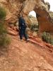
With all our gear fixed, we set off. It only took us fifteen minutes or so to hike up the road to Rainbow Trail. There we took a left and followed the trail as it contoured along the ridge. There were many tracks in the snow and could tell that the area was a popular destination even in winter. Soon we reached the crest of the broad ridge. We'd worked up some body heat since leaving camp and we all shed some layers and Alan found a faint trail that headed straight up the ridge.
We followed the trail through aspens and pines. The morning started off very cloudy but as we climbed the clouds began to clear a bit - raising our hopes that we might have a decent view of the Crestones. Soon we got our first glimpse of Humboldt's east ridge. The snow began to get deeper as we ascended. At the beginning of the ridge it was only a few inches deep but as we ascended the ridge until it was 10 inches deep in most places with drifts that were knee deep. After crossing several of these drifts Alan and I opted to put our snowshoes. Barry didn't have this option because he didn't bring any. He didn't own any snowshoes and was hoping that there wouldn't be that much snow. While Alan and I strapped on our snowshoes Barry pushed on ahead. We caught up with him atop a highpoint on the ridge. We were a little unclear as to which direction to head with the clouds obscuring all landmarks and us not remembering their being a highpoint on the ridge other than the summit. Barry did a little scouting while Alan and I checked the map. We all came to the conclusion that we should keep to the north and descend a little ways. This we did and even passed a couple of cairns so we knew we were on the right track.
After descending a bit we continued up the ridge. At this point the clouds cleared enough so that Humboldt's summit was occasionally visible. The snow also began to get deep and Alan and I were thankful for the snowshoes while Barry was spending precious energy floundering through the snow. Alan and I took turns breaking trail where we were regularly sinking knee-deep into the snow even with snowshoes. Of course, this meant Barry was sinking to mid-thigh. After what seemed like a long time we reached a clearing in the trees where it was looked as if timberline was near. It was 10:00am and we were at roughly 11,400 feet. We took the opportunity to grab a snack and make some clothing adjustments. We could tell that once we left the shelter of the trees that the wind would be brutal. Also we were beginning to get pelted with snow. It was difficult to tell if it was spindrift being blown of the ridge or if it was falling from the sky - likely it was a little of each. I bundled up with sweater, shell, balaclava, and overmitts and Barry and Alan did similar. The next hundred yards were through deep snow as we weaved our way through stunted pines before reaching timberline.
As feared, the wind was fierce when we left the shelter of the trees. We put our heads down and plodded toward the summit, which was coming in and out of view behind the clouds. Immediately the snow became scoured hard pack and snowshoes were more of a hindrance than a help. We shed them and left them behind as we plodded upward. The three of us spread out and hiked along at our own paces. The wind and snow were a difficult foe, but we battled on. It seemed like our progress was slow but we gradually clawed our way upward. I fixed my eyes on the apparent summit but when I was within a 50 feet of it I saw the mountain continue to climb away from it. I think my eyes were playing tricks on me because at first the summit appeared several hundred feet away. I felt a little dejected that that there was so much further to go, but when I squinted and peered again into the clouds and wind whipped snow it appeared that what I now thought was the summit was just another 50 feet beyond what I had previously thought was the summit. I gritted my teeth and pushed on.
I finally made the summit and peered back to check the progress of Barry and Alan. Barry was right behind me and Alan was a little way back. While I waited for them to join me on the summit I took a couple of photos. There wasn't a whole lot to see - the clouds quickly swallowed the ridges that extended from Marble Mountain. I pointed the camera in the general direction of Crestone Needle and snapped a couple of shots through the clouds and blowing snow. I could make out the frozen Lower South Colony Lake and maybe the first couple hundred feet of Ellingwood Arete, but that was about it. After snapping a few photos I found a relatively sheltered spot to await Alan. He staggered in a couple of moments later and took his own summit photos. I got Alan and Barry to pose for a group shot, set the auto-timer and joined them for the "hero shot". The wind was blowing so hard that both Alan and Barry thought that my camera wouldn't remain balanced on top of the summit cairn for the photos - but it did. Never the less after the camera went off I hustled back to grab it before it blew away.
It was frigid on the summit with the howling wind and blowing snow so none of us were interested in hanging out. It was also 1:00pm (it had taken us six hours to reach the summit) so we needed to hustle down if we were going to get packed up and down off the South Colony Lakes Rd before it got dark. With the ferocious wind at our backs we beat a hasty retreat down the ridge and made quick progress back down to where Alan and I had left our snowshoes. We strapped 'em on and continued down into the trees.
Progress was quicker during the descent. We cruised down through the deep snow and up and over the high point in the ridge. The rest of the hike was like a blur and we made it back to the car at about 4:30pm which gave us just enough time to pack off and hit the road before it got too dark. Barry drove us down the South Colony Lakes road without incident and stopped at my car so I could transfer my kit.
After that I followed Barry and Alan into Westcliffe for some more beer and pizza. Our eyes were much bigger than our stomachs however, and I ended up taking almost a full pizza home with me. After dinner made my farewells to Alan and Barry who were going to stay the night in Westcliffe before heading out and I hit the road by 6:30pm. The drive home was uneventful except for when I almost went the wrong way out of Florence - it was a good thing I asked for directions at the gas station! I was totally exhausted when I made it home but it was good to sleep in my own bed after the day's adventure.
Map [hide]
