


Huron Peak
|
|

Trip Report [hide]
This weekend was pretty crowded with stuff we needed to do - birthday party on Saturday evening and work on Sunday, but in my quest to knock out some fourteeners I was convinced I could cram one in. I'd finished of the Mosquito/Ten Mile fourteeners earlier in the spring so the next closest ones were in the Sawatch Range. Since we had to be back by 6:30 or so I asked around summitpost.org to see which were doable leaving Littleton in the morning and getting back no later than 6:30. The two suggestions I got were Huron and Princeton. It was pretty much a coin toss between the two so I arbitrarily chose Huron Peak.
I invited my dad along and I drove down to his house in Littleton Friday night. We woke up Saturday at 3:45 and were out the door by 4:15. We decided to drive up I-70 and up and over Freemont Pass through Leadville on the way to the trailhead and return via Buena Vista and US285 on the return leg. It was just getting light as we rolled into Leadville and we stopped at a convenience store for a restroom break and to pick up a few extra snacks. We were quickly on our way and soon turned off the highway onto CR390. As we passed Clear Creek Reservoir my dad was surprised to find it filled to capacity. This time of year, and with all the talk about drought etc he figured these high mountain reservoirs would be pretty low.
We cruised west on the CR390 for a ways until we hit Rockdale, which consists of a small group of cabins. Here there is a 4wd road that follows Lake Fork Creek south along the eastern flanks of Huron Peak. This sounded like a nice alternative to the standard route so we went to check it out. I'd heard that crossing clear creek here could be a little dicey so we drove down to take a look. Although the stream was a deeper than it first appeared we had no trouble getting across it. However, on the other side of the creek the first 20 feet of road looked too rough for the car to handle. So we turned around and reconciled ourselves to taking the standard route with the masses.
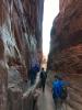
After a short drive further up CR390 we made our way through the ghost town of Winfield and passed the 2wd trailhead. This 4wd road looked a little tamer so I decided to drive up this as far as we could. It was about as rough as the road up to the Mount Lindsey trailhead but about two thirds of the way to the trailhead we came upon a section that scared me a little. There was a big dip to cross and the banks of it were sloppy muddy. I decided against trying thinking that this was good enough. I parked the car, Dad and I got our stuff together, and we took off up the road at 7:30. As we were just about to leave the car we were caught by a group of ten hikers or so. They were going just slightly slower than we wanted to go hiked behind them up the road. Before long we hit the 4wd trailhead. The group of hikers we'd been trailing stopped so we bypassed them and took the trail up Huron's western slopes. The trail switchbacked up the side of the mountain through the trees. Every once in a while we would get a glimpse of the Three Apostles to the south and we had an excellent view up into Silver Basin to the west. We broke through the trees at 8:45.
We stopped for a quick snack and rest before continuing across a broad, flat, grassy, basin. On the other side of the basin the climbing the trail kicked up and soon we were huffing and puffing. Looking up the trail we could see 20 to 30 hikers above us, and more were coming up from below. This was certainly not the mountain to climb if you're seeking solitude! The trail switchbacked up the tundra slopes and gained the Huron's north ridge about six hundred vertical feet from the summit. These last six hundred feet consisted of a muddy trail up through talus and boulders. The melting, recent snow and high traffic caused some of the footing to be muddy and slippery and this slowed us down a bit.
When we reached the summit at 10:30 it was totally socked in. Visibility wasn't much more than two hundred feet in any direction. There were about ten other people on the summit and we chatted, took photos of each other, snacked, and hung out while we hoped the clouds would clear so that we would have a nice view. Occasionally the clouds would shift and I caught a tiny glimpse of the Missouri group to the east. You could look down into the valley to the east and see the southern tip of Clohesy Lake and once in a while you could see north to Browns Peak. But the view I really wanted to see to the south of the Three Apostles never happened and the weather didn't look like it was going to improve. So after spending about twenty minutes on the summit we packed up and headed down. When we left there were at least twenty people on the summit.
The hike down was uneventful and we reached timberline at 12:15. As we crossed the wide grassy basin the clouds enveloping Huron Peak parted and I'm sure whoever was on the summit was able appreciate the view we were robbed of. However, storm clouds were building elsewhere and it was probably still a good idea that we got off when we did. As always surprises me, we passed people in the basin who were on their way up. They were in the neighborhood of two hours away from the summit and it was already past noon. We could hear thunder booming in the La Plata vicinity and things looked a little sketchy off to the southwest too.
As we hiked down through the trees there were times that I thought we would get rained on, but the rain never seemed to materialize. By the time we reached the valley floor the sun was out and shining. We walked back down the 4wd road to the car and arrived at 1:30. As we stowed our packs and pulled off our boots the weather seemed to be turning again and the clouds were moving in once more. We headed out as the clouds settled in. By the time we reached Winfield it was pouring. There were going to be a lot of wet hikers up on Huron Peak.
When we headed back down CR390 it was apparent that we were in the middle of a foot race. There were many numbered athletes running up and down the road. We saw a sign on the road and pulled over to read it. The sign said that parking was not allowed on the side of the road due to the Leadville 100 Trail Run. Another mile or so down the road we came upon what appeared to be a feed zone and there were support vehicles parked up and down the road. The runners were grabbing food and rain jackets from their support crews as they headed off of CR390 and up into the hills.
Past the race the going was uneventful and we pulled off CR390 onto Highway 24 and headed down to Buena Vista. In Buena Vista we stopped for a soda and then continued on up into South Park on US285 before dropping down to the Front Range. We made it back to my parents' house at 4:30 in time for a shower and a nap before it was on to the next event of the weekend.
Map [hide]
