


Quandary Peak - East Ridge
|
|

Trip Report [hide]
The plans for this trip had changed so many times it was hard to remember what the original plan was. Originally, this weekend was to be fourteener blitz. I was going to climb Democrat, Lincoln, and Bross on Saturday and then bag Quandary on Sunday. Julie and Poudre were going to come with me and we were going to play in Breckenridge or Fairplay Saturday afternoon and do some car camping in the area Saturday night. However, on Wednesday of the previous week I learned that I would be traveling on business the entire next week (8th through 15th). When we found out about my business trip, Julie and I decided to scrap the idea of a two-day adventure and I decided to change plans to a one-day trip. (There were several chores that I would need to take care of on Sunday before I could leave on the business trip.) Since Julie wasn't interested in climbing any mountains there really wasn't much point in her coming. So, the question was what mountain to climb? The weekend fourteener blitz could always wait, so I decided to try to join a fellow SP member in his climb of Peak C in Eagles Nest Wilderness. However, I was unable to contact him before the weekend so it was back to the drawing board (it was actually fortunate that I didn't end up trying to climb Peak C because Aaron's attempt was abandoned due to the weather). After some consideration I decided to do the Democrat, Lincoln, Bross loop.
My alarm was set for 3:30 and I rolled out of bed after one snooze. It only took me a few moments to get my gear together and then I was out the door. I hit 7-Eleven on the way out of town for a cup of coffee and a donut. By 4:00 I was headed out of town. It was cloudy and pretty cool in Fort Collins, and the weather got worse as I drove south toward Denver. As I made my way onto I-70 I passed through several little rain showers. By the time I made it to Idaho Springs it was raining steadily. All I could do was hope that conditions were better on the other side of the divide and press on.
They weren't. It was pouring rain as I pulled into Breckenridge at about 6:30. I was determined to go for a hike, but I was rethinking my decision to attempt Democrat, Lincoln, and Bross. I estimated this hike would take me about six hours, and hiking in the cold and rain for six hours could be miserable. Taking this into consideration I decided to attempt Quandary Peak instead. I estimated a round trip on Quandary would take me four hours, and I figured four hours out in the wet and cold would be better than six. There was one other thing I wanted to take care of. I had no way of keeping the stuff in my backpack dry. The fabric of my pack wasn't waterproof, and if I was out in the pouring rain for very long the water would soak through and drench my stuff. To fix this I decided to stop at City Market and buy some gallon-size Ziploc bags. I could then stuff my extra clothing into the bags and not have to worry about it getting wet if the rain continued.
With that task accomplished I made my way to the trailhead. I found what I thought was the trailhead without trouble and got my gear together. As I was making the necessary clothing selection the rain began to let up. I decided on wearing some shorts underneath my Gore-Tex pants and t-shirt with my little, fingerless, wool gloves. I figured that I would be generating enough body heat to keep myself warm (at least for the first few thousand vertical feet) and I wouldn't have to go through the trouble of putting on my Gore-Tex pants in a hurry if the weather turned. By the time I got all my gear squared away and hit the trail it was 7:00.
The rain had almost completely stopped and I made good progress toward my objective. The trail wound its way through the forest as it climbed the lower slopes of Quandary's eastern ridge. At one point I had a good view of McCullough Gulch and Quandary's northern slopes. I saw what I thought was Inwood Arete but clouds obscured Pacific Peak and Point 13,841. I snapped a couple of photos and continued on. Soon after that I saw a couple of deer and tried to snap a few photos of them.
After I saw the deer, the trail wound around to the south side Quandary's east ridge. From this vantage point I had an excellent view of North Star Mountain and up into the Monte Cristo Creek drainage. As I climbed onward the trees began to thin out and Mount Lincoln and Mount Bross began to come into view. They had a dusting of snow on them. As I continued hiking up the Quandary's east ridge, the clouds began to roll in. Far below in the Monte Cristo Creek drainage clouds were obscuring Blue Lakes. The clouds were also starting to engulf the top of the ridgeline around the drainage. Soon Lincoln and Bross were hidden from view and then summit of North Star Mountain was obscured. At about this time I passed two couples. These were the first people I'd seen on the trail.
The trail made a few switchbacks and then angled slightly toward the north on its way to obtaining the eastern ridge. I could see a single hiker up ahead and I focused on catching him. He had attained the ridgeline and was silhouetted against the sky. I quickly closed in and took several photos of him as I made my own way up to the ridgeline. I caught him at about 13,000 ft and we stopped to chat for a moment and take photos of each other. By this time the clouds had really moved in and the summit of Quandary was obscured. There were interesting looking clouds everywhere. Looking north there were all kinds of little tiny clouds. I took a really cool photo of Mount Helen. In it lots of small puffy clouds look like they're stuck to the side of the mountain.
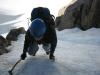
As I continued along the ridgeline the clouds began to really envelope me. Visibility rapidly went down and soon I couldn't see more than 200 ft in any direction. It also began to snow a little. I plodded my way up the talus and small boulders, steadily gaining elevation. As I got closer to 14,000 ft I began to get colder. I finally succumbed to the cold and stopped to make a clothing adjustment. I took of my sweat-drenched t-shirt and replaced it with my polypro turtleneck and put my jacket on over that. By the time I made my clothing adjustment it was snowing pretty good.
I continued up the trail and in another few minutes I reached the summit at 9:00. I was the first person on the summit and I looked around for the summit log. The summit log was brand new and I was the first person to sign it too. For the next few minutes I played with the autotimer on my camera and took some photos of myself next to the set of skis that mark the summit. After taking the photos, I was ready to go, but I kind of wanted to wait for the guy I had passed earlier so I could get him to take a photo of me and I could take his photo. I also wanted to get his contact information from him because I'd taken a couple of really cool photos of him and I thought he might want copies. So I sat on the summit in the snow and clouds and ate some trail mix. He showed up about 30 minutes after I reached the summit and one of the couples I'd passed early on followed only a minute or two behind him. I got his contact info and we all took photos of each other. I left the summit at 9:45 and headed back for the car.
As I made my way down, the snow petered out but the clouds remained dense. It was interesting to watch the hikers coming up emerge from the mists. I crossed paths with the couple I'd passed first and then I began to encounter other hikers more frequently. Since nobody could see the summit due to the clouds, everyone asked me how far it was to the summit. At first, it was easy to make a reasonable guess, but the further down the mountain I went the harder it was to estimate.
As I lost elevation I began to heat up in my jacket and turtleneck so I stopped to take the jacket off it. This was more comfortable for a few minutes but it soon began to rain lightly and I was forced to put my jacket back on. I'd say I might have passed as many as 40 people going up as I wound my way down the mountain.
At 11:15 I popped out of the woods and onto the road. Much to my consternation, this wasn't the same place that I'd begun my hike from and my car was nowhere in sight. I wasn't sure, but I guessed that the trailhead from which I started was further up the road, and I began walking in that direction. After I'd been walking along the road for a few minutes a car approached from further up the road. I flagged him down and explained my situation and asked if he'd seen my car. He said that he couldn't remember seeing my car but he guess I was walking in the correct direction. Thankfully he was right and I arrived back at the car at 11:30.
During the hike I had spotted some waterfalls in Monte Cristo Creek. I suspected that this is where my Great Uncle Darwin (my mom's mom's brother) used to take me when I was a little boy. I figured while I was in the area I should check it out and maybe snap some photos. I swung the car around and headed up the road toward Blue Lakes. I spotted the first waterfall down stream of Blue Lakes and pulled over to the side of the road. This was indeed the waterfall that Uncle Darwin had taken us too. I remember climbing up the side of it on the slippery, moss-covered rocks. I couldn't have been more than 10 years old at the time. I snapped some photos and then continued up the road in the car.
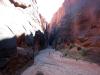
As I approached Blue Lakes I could see that the section of Monte Cristo Creek that separated the lower and upper lakes appeared to be almost one long continuous waterfall. I decided to drive up to the upper lake and park there. I hopped out of the car and scrambled down to the creek. I worked my way down the creek from the upper lake to the lower lake snapping photos as I went. This was pretty fun and in places I had to be really creative to find a route down that stayed next to the creek. The creek started off with a series of cascades and then it entered a narrow little canyon with a ledge overhang. It almost felt like a tunnel with the rock overhang. The walls were tight here and I had to hike through the creek a little ways and then cross over to the other side. The steep canyon-like walls opened up for a hundred yards or so and then the creek spilled out over a large flat rock. I set up the camera with autotimer to snap a picture of myself next to this waterfall. After that I was forced to leave the side of the creek and scamper across some rocks and through some trees to reach the bottom of the last waterfall. I snapped a couple of photos of this one and then made my way back up to the car.
I made it back to the car at about 13:00 and changed out of my Gore-Tex pants and boots and into some sandals for the car ride home. The drive home was uneventful and I only encountered a little slowing of traffic at the west side of Eisenhower Tunnel and right before the Georgetown Grade. I arrived back at home in Fort Collins at 16:00. In hindsight I probably would have been fine doing the Democrat, Lincoln, Bross loop, but I guessed it was better to be safe than sorry. Those mountains weren't going anywhere. However, I thought the fourteener season might be over for me. I wasn't going to have a free weekend until September 27th and at the rate the weather was turning in the high country there would probably be some considerable snow on the fourteeners by then.
Map [hide]
