


Clark Peak
|
|

Photos [hide]


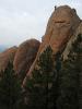
 on the left and Point 12,654 on the right fr...")


, I decided to go for it. The first part of th...")


Trip Report [hide]
Day 1 -- August 30, 2003
I had my alarm set to go off at 6:00, but when it went off I wasn't ready to get up so I set it for 7:00 and went back to sleep. The night before, Julie and I went over to the neighbors' and played Trivial Pursuit and drank beer until midnight. Consequently I wasn't too quick to jump out of bed. When the alarm went off at 7:00 I was a little more ready to start the weekend's adventure and I slid out of bed and took a quick shower to help wake up. I was all packed up so all I had to do was grab my bottles of Gatorade out of the freezer, fill them the rest of the way, and jump in the car.
This adventure was to be a solo trip. Julie never recovered from the migraine she developed during our Holy Cross trip. After that weekend she continued to get migraines throughout the following week, which wasn't normally how they occurred for her. (Usually she gets one every couple of months, not several in one week.) She went to her neurologist and he diagnosed her as having a static migraine. This is a migraine that never completely goes away and flares up frequently. The neurologist put her on one medication regiment without success. Now Julie was just beginning a second medication regiment, but it was too soon to tell if it would work. Since Julie wasn't going, I decided to leave our dog Poudre at home too. I wasn't sure how tough the climb of Clark Peak would be and I didn't want him cramping my style like our experience on Nokhu Crags. As it turned out, he probably would have been fine climbing Clark Peak, but he would not have been happy about the weather conditions during the weekend. Poudre doesn't do well in the wet.
Anywho, before I began the drive to West Branch Trailhead I stopped at 7-11 for a cup of coffee and a donut. With breakfast in hand I set out for Rawah Wilderness and Clark Peak. A massive cold front had hit Colorado the night before and he weather did not look good. It had poured the night before steadily for at least four hours and the clouds had not left. They were hanging really low and it was pretty cold out. When I entered Poudre Canyon the clouds were about 200 ft above the river. They stayed at about this level all the way up the canyon. The only good thing about the weather was that it wasn't raining.
I got stuck behind several cars on the way up the canyon, but they were moving fairly quickly. I turned off Highway 14 and wove around Chambers Lake. It seemed like the clouds were hanging a little lower here, maybe only 100 ft above the surface of the lake. I stopped at the north end to take a photo. After that I descended along the Laramie River to West Branch Trailhead. The parking lot was about half full and there was another couple getting their gear together as I put on my socks and boots. Rain looked imminent, so I slipped on the pack cover that my in-laws had given me the previous Christmas. It was a little chilly, about 45 degrees so I put on my polypro turtleneck and the legs to my convertible pants.
With my kit squared away, I locked up the car and set off. After crossing the Laramie River the trail headed west up the West Branch. The skies looked very ominous. Dark clouds obscured the peaks of the Medicine Bow Mountains and low clouds filled the valley I was headed up. As I entered the forest raindrops began to fall. The rain wasn't enough for me to need to put on raingear, and because I was slightly sheltered by the trees I hardly noticed it. It was only when I looked out across the valley to the south that I could see the rain coming down in light sheets. I set a swift pace and quickly passed the couple I saw gearing up in the trailhead parking lot. I chatted with them for a moment and asked where they were headed. They had never been to Rawah Wilderness and were on a day hike. They said they were thinking about going up to Twin Crater Lakes. I said that this was a good choice and that it was very pretty up there.
I continued on and reached the junction with Camp Lake Trail at 10:00. I had been overheating almost the entire hike so I took a break and took the legs off my convertible pants. This helped and I felt a little better as I hiked toward the crossing of the west branch of the Laramie River. I made it to the crossing in another thirty minutes. The bridge hadn't been repaired since the last time we were up here over Fourth of July Weekend so I decided to wade across rather than risk a fall in while crossing the single log that spanned the river. While I was taking my shoes and socks off a guy and his dog approached the river from the opposite shore. This fellow had the balance and confidence to cross over the log. He made it successfully but the strain of the maneuver showed on his face when he made it to safety on my side of the river. We chatted for a few minutes. He said he had begun his hike yesterday but set up camp near the switchbacks on the way to Twin Crater Lakes. He said it had rained hard the previous night and again this morning. He said he and all his gear were pretty much soaked and then when his stove broke that was the last straw. He had decided to cut his losses and turn around and head back to the car before things got even more miserable for him. I sympathized with him for a few minutes and then I waded across the river while he set off for his car. I hoped I would have a better weekend than he did.
The water in the river wasn't as cold as I thought it would be and I quickly dried my feet off and got my boots back on. I moved along up West Branch Trail. The area suddenly became much more lush and wet and the grasses and low shrubs encroached on the trail and brushed up against my legs as I hiked. There were also lots of big puddles in the middle of the trail. I tried to avoid stepping in these, as I didn't know how deep the mud would be. In another forty-five minutes I reached the junction of West Branch Trail and Blue Lake Trail at 11:15. I took the opportunity to rest here and grab a snack. While I caught my breath the rain picked up. It had been sprinkling and misting off and on throughout the hike but had it had never been significant enough for me to get out my raingear. Now however it was raining hard and I was forced to get out my rain jacket. I exchanged my polypro turtleneck with a t-shirt to try to avoid overheating and then slipped on the jacket. With this clothing adjustment made I set out in the rain. It began to rain harder and harder and my socks and shorts were getting wet so I stopped again and put on my rain pants. I set out once more continued along in the rain. I slowed my pace so try to avoid overheating, but this only helped a little. Soon I was wet underneath my jacket from sweat, but at least I was warm.
I soldiered along in the pouring rain. Now I was really glad that Julie and Poudre were not with me. They would have been miserable. We don't have a pack cover for Julie and she doesn't have rain pants. We could have improvised a pack cover out of trash bags but there wouldn't have been anything we could have done for her legs. Poudre too would have been miserable. His terrier fur isn't made for getting wet. When he gets wet he looks like a drowned rat. Anywho, I made slow progress up the trail until I reached a major stream crossing. On the other side was a couple with a pair of llamas. This party was leaving the trail and bushwhacking their way south. There were a couple of large logs lying across the stream that I would have crossed under normal circumstances. However, they were slick with rain and looked slippery. I decided to venture up the stream a little ways and find a place where I could cross bigger, more stable rocks. I found a spot and made my way across. My trekking poles were invaluable during this maneuver. Without them I probably would have lost my balanced and landed in the stream.
Although I figured that the couple with the llamas was headed to Timber Lake (because where else would they be going?), I didn't want to follow them. I figured we still had several hundred feet of elevation to gain and I'd rather do that on a nice trail, not bushwhacking. I also believed that the bushwhacking that I would have to do would be much easier at higher elevations where the vegetation would be sparser. Here it was pretty thick. So I continued up the trail for another fifteen to twenty minutes. When the trees began to thin, and the trail began to get steeper, I decided to leave the trail and head south. Initially I had to weave my way through some stands of trees but soon I popped out into a pretty meadow. I crossed this meadow and then worked my way through a thin band of trees into another meadow. It had been pouring continuously without letup and with no end in sight. However, I was feeling pretty good. My pack looked to be staying dry and my upper body was warm, though a little damp from sweat. My legs were dry and warm and my feet were warm, but starting to get a little wet. As I gazed across the meadow I could spot some rock outcroppings. These didn't look negotiable, so I'd have to go either below them or above them. I knew that there was a cool waterfall coming out of the northeast side of Timber Lake so I assumed this implied a steep slope. Consequently I decided to skirt around the upper side of the rock outcropping hoping to avoid the steep slope.
This I did, and after rounding the rock outcropping Timber Lake opened up a hundred feet or so below me. I strolled down to it and looked for a good spot to pitch the tent. I found one nestled underneath a stand of pine trees. The rain had letup a little and the trees sheltered the spot so I was able to pitch my tent without getting it too wet in the process. I sorted out my gear and crawled into my sleeping bag. During the last part of the hike my feet had become totally soaked and I was really glad to get my boots and socks off and warm up my feet in my sleeping bag. I was a little disappointed in my boots. They have Gore-Tex liners and I was wearing my Gore-Tex pants that came down over the top of the boots. I couldn't imagine that water would have made its way into them from the tops. The only thing I could think of was that water soaked into them from brushing against wet shrubs and grass and this was what I thought the Gore-Tex was supposed to prevent. Never the less, if this was the worst problem I had all weekend I would have done pretty well. I curled up and went to sleep.
I awoke several hours later to find that the rain had stopped. I piled out of the tent and got some clothes on. I decided to explore the Timber Lake area. In particular I wanted to find the waterfall I'd read about. I walked around the lake clockwise until I hit the outlet. I was surprised to see how fast the water was flowing out of the lake. You could see the current out in the lake twenty or thirty feet where the water was rushing toward the outlet. I followed the outlet downstream a little ways looking for a place to cross while I skirted clumps of dense brush and the occasional tree. When I found I good place to cross I hopped across the stream. It was only another twenty or thirty feet before I stumbled upon the waterfall. The waterfall consisted of two parts. The top part was a not quite as steep and tumbled down a staircase-like set of rocks for perhaps 100 ft. It was easy to scramble right along the flowing water on the boulders that lined the course of the waterfall. When I got down to the bottom part of this section of the waterfall the stream turns a sharp corner and then really falls off a steep drop-off. I snapped a few photos of the top section of the falls and then looked for a way to get down to the bottom of the second section. I ended up scrambling down a crack in the rock to the south of the waterfall. It was really slippery with moist duff and rocks that weren't solidly imbedded in the dirt slope. When I got to the bottom of the slope I snapped a few photos of the waterfall. From the valley floor I had an excellent view of the peaks and saddle that separated Carey Lake and Twin Crater Lake (the same saddle that Larry, Michael, and I climbed during our 2002 backpacking trip). They waterfall in combination with this view was an impressive site and I hoped my snapshots turned out.
After I had my fill of the waterfall I headed back up to my campsite to get my fishing kit together. I tied on a trusty beadhead zugbug and headed for the lake. The portion of the lake closest to my campsite was very shallow, perhaps only three feet deep so I chose to circle around counterclockwise. I crossed over the stream that feeds Timber Lake and strolled along the southwest shore. This is where the boulder field meets the lake and it was much deeper here. I tossed my fly out there and waited to see what would happen. Nothing happened. I fished for perhaps an hour without a hit, or seeing anything cruising or rising. I resisted the temptation to circle farther around the lake because I didn't want to get too far away from my tent. The skies were looking angry again with purple clouds bubbling over Clark Peak. Soon the clouds were spitting rain and I took this as my cue to beat a hasty retreat to my tent. By the time I got situated in my sleeping bag at 17:00 it was pouring rain.
I read and dozed until about 19:00. At this time I was only hearing a few drops hit my tent so I figured the rain had let up enough for me to venture out of the tent. When I got out of the tent I realized that the drops I was hearing were coming off the trees sheltering my tent and that it had probably stopped raining twenty to thirty minutes ago. When I stumbled out of the tent there were a pair of fellows with their two dogs nearby. We chatted for a few minutes. They'd seen my fishing rod and asked me how the fishing was. I told them not so good thus far. They had started their backpacking trip at 21:00 the previous night and hiked in the dark a ways until the set up camp at midnight several miles farther down the valley. They'd arrived at in the Timber lake vicinity around 15:00, probably while I was messing around at the waterfall. They continued their stroll around the lake and I got some water on for dinner. As I waited for the water to boil I gazed up at Clark Peak. The summit had received a light dusting of snow from the storm and looked really pretty with the last rays of the setting sun hitting it. When the water boiled I poured it into my dehydrated Chicken Polynesian dinner. While I waited for my dinner to reconstitute I grabbed my rod and headed down to the lake to fish a little.
I didn't want to stray too far from the campsite so I just went down to the nearest spot where the lake was only three feet deep. I tossed the zugbug out there and after a few casts I had a hit. In another couple of casts I hauled in a little Greenback Cutthroat. This fellow was only about five inches long but he was pretty. I tossed him back and fished a little more. In another few minutes I reeled in another five-inch Greenback. I tossed him back too and then went to go eat dinner. I'd probably been fishing for about twenty-five minutes and when I got back to my dinner it was only lukewarm. It was still good though and I was glad that I could at least say I caught some fish up here instead of being completely skunked.
I finished up dinner at about 20:00 as it was getting dark. I straightened up the campsite and put all my gear away and snuggled into my sleeping bag. I set my alarm for 5:30 because I wanted to catch the sunrise and morning glow on Clark Peak. I read until 21:00 or so before turning off the headlamp for the night and turning in.
Day 2 -- August 31, 2003
I awoke to my alarm and opened up the tent to take a peek outside. It was pitch black and I couldn't see a thing, including any stars. I closed up the tent and went back to sleep. I awoke again at 6:30 and took another peek outside. I could now see a faint glow to the east, but the skies were thick with clouds and I could tell that there would be no spectacular sunrise or morning glow. I went back to sleep.
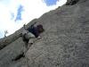
I awoke once more at 8:00. This time I was ready for the day and got dressed and rolled out of the tent. When I turned to gaze up at Clark Peak I was discouraged to find it completely socked in. Thick clouds swirled around its summit and the ceiling looked to be about 12,250 ft. I had some trail mix as I pondered what to do next. After thinking about it for a minute I decided to go for it. It wasn't raining and I hadn't heard any thunder or seen any lightning all weekend. I figured conditions were just as likely to get worse as better. I also figured that I could always turn around if things got bad, and I wasn't really at any risk until after I had passed the unnamed tarns north of Clark Peak. Up until that point it would be easy to turn around and I wouldn't be anywhere requiring technical moves, or on any exposed ridges or anything. With the decision made, I saddled up and set out.
I began by wearing almost everything I had: polypro turtleneck, wool sweater, jacket, stocking cap, wool gloves, shorts, and Gore-Tex pants. In addition I had a pair of long underwear bottoms and a set of dry socks in my pack. Initially I headed out following the stream that feeds Timber Lake through a beautiful meadow. Within five minutes I had warmed up to the point where I didn't want my jacket on anymore and I took it off and stowed it in my pack. In another ten minutes I reached a point where the stream veered into a thick maze of willows. I parted from the stream and worked my way around the willows to the north. I continued up the meadow trying to avoid the patches of willows whenever possible. Before I new it I had passed the unnamed tarns north of Clark Peak.
At this point I was nearing the cloud ceiling. I was at roughly 11,300 ft and the clouds were rapidly descending on me as I ascended into them. By the time I reached 11,500 ft I could no longer see the tarns, though I was still really close to them. I climbed my way toward the top of the knob. The clouds had totally surrounded me and I couldn't see any more than 200 ft in any direction. I was also getting a little cold. The wind was blowing steadily out of the west and my ears and face were cold despite my stocking cap. The wind was also cutting through my sweater and turtleneck. I decided to shed my sweater and exchange it for my jacket. This way I could also put up the hood to shield my ears and neck from the wind. With this clothing adjustment made I continued on to the top of the knob north of Clark Peak. I decide to climb out to the edge of the knob. It wasn't long until I reached the edge. There was a pretty sheer, several hundred-foot drop-off down to the boulder field below. I figured that by hugging the ridgeline I would reduce the probability of getting disoriented and lost in the mists. I had forgotten to take my compass so this was something I really had to pay attention to. If I got turned around and headed the wrong way off the summit of the mountain, or climbed the wrong mountain and didn't realize where I was I could be in a world of hurt. There were a couple of things I had going for me: (a) the wind was steadily blowing from west to east and (b) I should be able to hug the ridgeline all the way to the summit. I hoped that these two things would keep me from getting lost.
I followed the ridgeline south below Point 12,654. My clothing adjustment had been perfect and I was now completely comfortable. From the top of the knob up to this point it had been more or less flat. After crossing below Point 12,654 the climb began to get steep. The tundra also gave way to boulders so I stowed my trekking poles on my pack so that I would have both hands free to aid my ascent. I climbed the boulders for a while. The clouds were very thick here and from time to time large rock outcroppings would suddenly loom out of the clouds. It was pretty eerie. However, there were many little birds flitting about to keep me company. As I continued on the rocks became slick from all the moisture in the air and I started to see little patches of half melted snow and ice. I assumed that this was the remnant from yesterday afternoon's dusting of snow. After climbing the boulders for a few minutes, the terrain changed to talus. The mountainside was now a sheet of fist and plate sized rock. It was slick and gave way as I trudged up it. Many of the rocks were now covered with snow, making the going that much more treacherous. It was really discouraging to be only able to see 200 ft in any direction because I had no idea how much further the summit was.
I continued climbing, make slow but steady progress. The steepness of the slope seemed to let up and then all of a sudden a wind shelter emerged out of the gloom and I was on the summit. I took of my pack and walked around the summit for a minute. I wandered a little ways toward what I thought was the northeast ridge. I had really wanted to get some good photos of this because it looked like an interesting climb. However this was not to be because I couldn't see a thing. I also didn't want to wander out of site of the wind shelter. After going as far as I dared toward the northeast ridge I returned to the summit and sat in the wind shelter and had a snack while I played with my camera. It was new and I was trying to figure out how to use the autotimer. When I got that figured out I set the camera out on the summit and took a photo of myself sitting in the wind shelter. Whoever had built the wind shelter knew what they were doing because it did a perfect job of blocking the wind. I would have stayed there for a while except that sitting on the cold, damp rock was making my butt cold. If it weren't for my cold butt, I might have hung out on the summit for a while to see if the clouds would clear and I could snap a couple of good photos. However, I figured conditions were just as likely to get worse as they were to get better. It felt like it could start snowing again at any minute. So I packed up my stuff and headed down the mountain at 10:00.
The talus slopes were very slick on the way down. Many of the larger pieces (plate-sized) had a light dusting of partially melted snow on them and the ones that didn't were slick from the mist. I new that I was likely to slip and fall so I put my camera in the breast pocket of my jacket instead of having it in the pocket of my shorts. This turned out to be a good idea because I slipped and fell on my butt several times. If I had smashed our new digital camera Julie would have killed me. Soon I made it off the talus onto the more stable boulders. Now that I had learned how to use the autotimer on the camera, I stopped to take a couple of photos of myself descending Clark Peak. Once on the solid boulders I quickly made it down to the saddle between Clark Peak and Point 12,654. At this point there was a large snowfield spread across a relatively gentle slope leading towards the boulder field. Just beyond the snowfield I could see a ledge. I wasn't sure how steep the slope was after the ledge, but I decided to find out. If I couldn't find a way down beyond the ledge all I would have to do was climb back up alongside the snowfield to return to the saddle. If things worked out then I would have found a variation on the route that across the boulder field.
I had my trekking poles with me so I felt confident with a full-fledged glissade down the snowfield. I walked out into the middle of the snowfield, sat down, and let her rip. Unfortunately the snow was hard and rippled (like the sand on a wet beach) and my ass bumped up and down on it as I descended. Otherwise it was a fun glissade with no obstacles to worry about besides stopping at the bottom. I used my trekking poles to help stop me at the bottom and stood up. My butt was a little sore from bumping along the hard snow and I had a massive wedgie. Otherwise it was really fun. I walked across the ledge and looked out over the edge. In most places the drop was much to steep for me to go down. However, the snowfield I'd just descended fed a tiny stream that flowed down a steep, talus-filled gully. Although steep and loose, this looked doable. I carefully made my way down the gully, but I couldn't keep from kicking down lots of loose rock.
Without too much trouble I arrived at the top of the boulder field. Slipping and sliding down the gully wasn't too bad, but going up it probably wouldn't be much fun. I thought the way I had gone up was much more pleasant. The view to the north was also really impressive. I just couldn't get over how cool the peaks surrounding Island Lake and Carey Lake looked. Their summits were cloaked in fog and the whole scene was just awesome. I couldn't believe that none of them had names or even elevations stamps on the USGS quad map! I couldn't resists snapping photos in that direction. By the time I got back to camp I had something like fifteen photos of the exact same thing!
When I could tear my eyes away from the views I worked my way down the boulder field. I hadn't realized how big it was until I was in the middle of it. It was vast! I'd say it was much bigger than Longs Peak's boulder field. This was perhaps twice as long as Longs Peak's and the boulders were much larger on average. There was a grassy island in the boulder field close to Clark Peak's northern face and I aimed for that. When I got there I set up the camera to take a photo of myself with those peaks that mesmerized me in the background. The photo turned out kind of funny because I had shed my jacket. I was now wearing my black polypro turtleneck, my black Gore-Tex pants, and my black stocking cap. I looked like the stereotypical burglar in all black! After the short reprieve of grass I was back in among the boulders. I stopped two more times down the boulder field to take photos of myself. With the first one I wanted to give an idea of the size of the boulder field and the size of the boulders themselves. I carefully balanced the camera on a big rock and set the autotimer and tried to race around to the front of the boulder and onto another one. It was a little far to go in the few second the timer gave me and it took four or five tries to get it right. The second photo I took looking back up at Clark Peak with me sitting on a boulder in the foreground. The clouds still concealed the summit, but the ceiling had risen enough that you could now see the saddle between Clark Peak and Point 12,654. By 12:00 I was back at Timber Lake. I'm sure if I hadn't been dorking around with the camera so much I could have cut at least thirty minutes off the descent time.
When I arrived at the southwest shore of Timber Lake there were several guys fishing. Two of them were holding fly rods and the other two (a father and son) were using spinning gear. I strolled up to them and asked how it was going. They told me that it wasn't going well. None of them had so much as seen a fish. The two dudes with fly rods had been up to Timber Lake many times in the past and said that the fishing could be quite good if you hit it right. I told them I had caught a couple of little ones the night before, but when I told them it was in the very shallow section they didn't seem too interested.
I walked back to my tent and unloaded my daypack. The skies were looking threatening again so I packed up all my gear away so that if it started raining again I could just dive into the tent. With everything squared away, I grabbed my rod and set out to catch some fish. I decided that if the fishing was good, I would spend another night at Timber Lake and head back to Fort Collins tomorrow morning. If it was bad, I would take a short nap and then head back that evening. I figured it to be somewhere between three and four hour hike down to the car. So even if I left as late as 17:00 I wouldn't get back too late.
From my tent I worked my way around the lake clockwise. I didn't have any luck at the shallow end and I worked my way further around to where the lake was deeper. The father and son circled around the lake and passed me on their way to their tent. I wasn't having much luck so I continued on. I had yet to see any surface action, see anything cruising, or get a hit. I continued circling around the lake and passed the father and son's camping spot. I liked it more than mine. I made a note that next time I come up here I'll camp on the north side of Timber Lake. There was a little bay on the north side of the lake and this was the only place I had any luck. I had a couple of hits and a pulled in a fish. He was a little Greenback about the same size as the ones I'd caught the previous night, maybe six inches. I tossed him back and continued to fish but I didn't get any results after that one fish. I continued working my way around the lake but I didn't have any more results.
On the way back I passed one of the guys I had talked to earlier with the fly rod. This time he had a spinning rod. Even with that he hadn't had any luck. This made me feel better about not having mine. He said that in the past he had really good luck at Timber Lake and had pulled eighteen inch Greenbacks out of it. We talked about the other lakes in the area for a while. When I told him I'd been to Bench Lake his interest was peaked. I told him that we always (well both times) caught lots of ten-inch Brook Trout there, but that bigger fish could be found in Rockhole Lake. I wished him luck and then headed for the tent for a quick nap.
It was about 13:30, and I set my alarm for 15:30. I don't think I really slept, but it felt good to lie down and rest my legs. It also was nice to take off my boots and socks. My boots had been soaked all weekend so there wasn't any point in putting on dry socks. Consequently I'd been wearing wet boots and wet socks all weekend.
After the rest I was ready to get rolling. My alarm hadn't gone off yet so I wasn't sure what time it was. When I looked at my watch it said 15:26. I packed up camp and got everything squared away. The skies looked ominous, but they'd looked ominous all day and it hadn't rained yet. Since my hike out would be descending all the way I figured I was hiking away from potential rain. Thus I decided not to put the rain cover on my pack. When I had everything ready to go it was 16:15. I threw on my pack and set out for the car. It only took my fifteen minutes to cross the two meadows and bushwhack my way back to West Branch Trail. In one of the meadows I spotted a couple of hunters in their orange vests. They were several hundred feet away and I didn't want to shout to say hello in case it would scare off the game. At the same time I wanted them to know I was there so they didn't accidentally shoot me. I think my trekking poles made enough noise as I clattered across some rocks that they noticed me. Anywho, I didn't get shot so I guess things worked out. It took me another thirty minutes to reach the junction with Blue Lake Trail. I stopped for a snack. I had a couple of handfuls of trail mix and an energy gel before soldiering on.
It took me another forty minutes to reach the stream crossing at 17:40. I waded across the west branch of the Laramie River and then took my time drying off my feet and slipping my socks and boots back on. I also pounded another energy gel before saddling up. I just slugged along for the rest of the hike. I was tired, but at the same time I was pretty pleased with how I was doing. I encountered another hunter on the way down. He was using a bow and said he was going after deer. I wished him luck and continued on. I arrived back at the trailhead at 19:00. It felt great took take off my wet shoes and socks for the last time. The were smelling pretty ripe so I put all that stuff in the back of the car and hoped I wouldn't be smelling it on the way down.
As I drove up Laramie River road to Highway 14 the sun was setting over Cameron Pass and I stopped by Chambers Lake to snap a photo of it. On the way down I thought there would be no traffic, since it was only Sunday night of the three-day weekend. I was wrong, and before I'd even gotten through Rustic I was stuck behind a long line of cars going slower than the speed limit. Oh well--I cranked the stereo, opened the sunroof, and rolled down the canyon and into Fort Collins. I got home around 21:00, took a shower, and fell into bed.
Map [hide]
