


Iron Mountain
|
|

Trip Report [hide]
I hadn't been out hiking in two weeks so I was really looking forward getting up into the high country this weekend. Nelson and I had been tentatively planning on doing something so as the time drew closer it was time to decide. Nelson nominated Storm Peak for a second try, but I was hoping to try something else. Nelson then nominated Shoshone Peak, but with the road closed and a lot of likely snowshoeing I wasn't sure I'd be up for such a long day. So as an alternative I nominated Iron Mountain at the north end of the Never Summer Range. This peak had caught my eye the previous summer when I'd spent a weekend up in the American Lakes basin. It looked like a pleasant hike and should offer some spectacular views. Nelson had invited one of his friends, Jeff, who agreed with me that Shoshone Peak might be a little too much for us to bite off. So Iron Mountain it was.
On paper the hike looked really easy: under three miles one-way, about 2000 ft of net elevation gain, and all class-one, tundra slopes except for the first quarter mile which would be a steep bushwhack in possible deep snow. It turned out to be a little bit more of an adventure than I'd anticipated - making for a great spring day!
Nelson and Jeff swung by my house at early Saturday morning and we headed up Poudre Canyon. This time of morning there was absolutely no traffic and we made it to the top of Cameron Pass in about an hour and a half. We spent a while getting our gear together and deciding on whether or not to bring the snowshoes. The snow on the west-facing edge of Iron Mountain's northwest ridge was pretty deep, but Nelson and Jeff thought it wouldn't be that bad if we could circle around and ascend a south-facing slope. So we left our snowshoes in the car (this turned out to be the correct decision) and set off.
We crossed Highway 14 and headed up the dirt road that parallels Michigan Ditch. We followed this for a little over a half-mile until we found a gully that ran west up to the ridge. The northern side of this gully was relatively free of snow and looked like our best bet. We hiked up the ridge paralleling the stream rapidly gaining elevation. It was a little cool to start out with but now that we were working pretty hard it was t-shirt temperature. After a little while the trees began to thin and we popped out into a meadow. From here we could see the high point to the ridge northwest of Iron Mountain but we couldn't see Iron Mountain. I would learn later that this high point is a ranked 12er and is known as Table Iron. From this vantage point it looked like we had two options for attaining the ridgeline. We could veer north and attain the ridge north of Table Iron, or we could hug the western face of the ridge and contour along it until we reached the saddle between Table Iron and Iron Mountain.
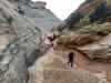
We decided upon the latter and headed pretty much due east to the foot of Table Iron's base. We crossed the meadow and then ascended the opposite slope. This was primarily west facing and had some pretty deep snow. Luckily it was pretty firm and there was only occasional post holing as we made our way up it. Soon we reached timberline and were rewarded with excellent views of the Never Summers to the southwest and Table Iron's craggy western face. We contoured along the base of Table Iron's west face for a quarter mile or so until we came to a large, flat spot. We paused for a moment for a breather and a quick snack. As we gazed to the south our choice of contouring along the base of Table Iron to the saddle looked less and less attractive. The slope was all scree - marble sized rocks where I was sinking to my ankles with almost every step. We had about a half-mile of this to go and trudging through the scree wasn't going to be all that fun. However, an alternative presented itself in the form of a step gully that extended from where we stood up to the summit of Table Iron. After a short discussion we decided to give this a try.
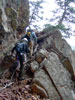
The run out of the couloir was covered in consolidated snow so going up this was much easier than it would have been if the snow had been gone and we'd been forced to trudge up the scree. Nelson estimated the slope to be 35-40 degrees and it had me a little uncomfortable. Nelson and Jeff were experienced snow climbers, but this was my first time on anything like this. I think what was making me nervous was the fact that there was nothing to hold onto if I lost my balance. With the clean run-out Jeff assured me that I wouldn't really get hurt too bad if I fell - it would be equivalent to crashing my bike. Nice. I decided not to fall. With Nelson and Jeff leading the way we made it up the snow slope where it ended in some rock scrambling. The wind was really howling down the gully so when we made it to a stopping spot we all made a clothing adjustment. We all put on gloves and warmer layers and Jeff and Nelson put on stocking caps.
After the clothing adjustment we completed the class-three rock scramble. This turned out to be a relatively short section, perhaps only 20-30 feet in the very middle of the gully where it was its narrowest. After the rock scramble the gully widened up into a talus slope that we quickly scrambled up to reach the top of Table Iron. The gully had been a really fun part of the climb and I was glad that I had done it with Jeff and Nelson. I really like doing stuff like that - situations that push my comfort level - with guys that have been around the block. It had been just the right amount of challenge for me - thrilling without being too scary.
On top of Table Iron the wind was really whipping out of the west so I stopped to put on my stocking cap. After that we strolled down the ridgeline to the saddle between Table Iron and Iron Mountain. From there it was a straightforward ascent up the last 500 feet to the summit. This went quickly and soon we were on the summit. Even though it was pretty windy we spent a good forty-five minutes on the summit snacking, snapping photos, admiring the view, and signing the summit log. The last entry was from October 2003. One of the things we talked about while on the summit was the route we should take back to the car. The way we had come was not really an option. That left either going back up and over Table Iron or descending down to the west from the saddle that connects Iron Mountain with Table Iron.
We decide to postpone the decision until we descended back down to the saddle. The weather seemed to be turning and ominous clouds were building off to the west so off we went. It only took us a few minutes to reach the saddle and we peered down the west side. We could see Michigan Ditch and the road that parallels it down below. It didn't look too far but the bushwhacking to achieve it might be a little painful. What's more, once we got down to the ditch there was the matter of crossing it, as the road was on the opposite side. We decided that the bushwhacking and the post holing we were likely to experience would be about as painful as ascending the 300+ feet back up and over Table Iron. We also decided that we'd deal with the ditch when we got there. In the worst-case scenario we'd have to wade it or bushwhack through the trees on this side of it until we could find a bridge or something to cross.
With the decision made we descended down to Michigan Ditch. The first quarter mile or so went quickly with the upper part a descent down tundra and talus until we reached some snow and then a couple of short glissades. As we descended we got out off the wind and the extra clothing began to come off. Once we got into the trees though things slowed down as we thrashed our way through the snow. It was deep and wet and with every fourth or fifth step we were sinking up to our thighs. After about a half hour of this the snow began to thin out and the going was easier until we hit the ditch. Michigan Ditch didn't turn out to be as big a deal as I'd feared. We found a place where it was only about seven feet across and three inches deep. Jeff and I were able to jump it with only one footstep in the middle. Those of us with shorter legs had to take two steps, but I think we all made it across without our feet getting wet.
Once on the road it was a quick and easy stroll back to the car. There were some flurries in the air and the temperature seemed to be dropping as we piled our stuff into the car. I was glad we made it back when we did. The ride down the canyon was uneventful, though there was considerably more traffic than early in the morning. What an excellent day!
Map [hide]
